Please use this identifier to cite or link to this item:
https://hdl.handle.net/20.500.12544/4639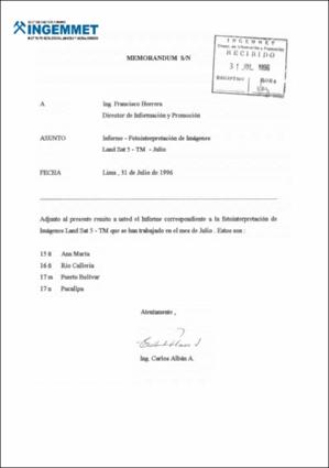
Files in This Item:
| File | Description | Size | Format | |
|---|---|---|---|---|
| A5906-Fotointerpretacion_imagenes_Ana_Maria.pdf | Informe Técnico A5906 | 479.62 kB | Adobe PDF | View/Open |
| A5906-Mapa_Ana_Maria.jpg | 4.73 MB | JPEG | View/Open | |
| A5906-Mapa_rio_Calleria.jpg | 4.78 MB | JPEG | View/Open | |
| A5906-Mapa_Puerto_Bolivar.jpg | 4.53 MB | JPEG | View/Open | |
| A5906-Mapa_Pucallpa.jpg | 5.13 MB | JPEG | View/Open | |
| A5906-Imagen_satelital_Ana_Maria.jpg | 18.43 MB | JPEG | View/Open | |
| A5906-Imagen_satelital_Puerto_Bolivar.jpg | 18.52 MB | JPEG | View/Open | |
| A5906-Imagen_satelital_Calleria.jpg | 17.92 MB | JPEG | View/Open | |
| A5906-Imagen_satelital_Pucallpa.jpg | 8.54 MB | JPEG | View/Open |
This item is licensed under a Creative Commons License


