Please use this identifier to cite or link to this item: https://hdl.handle.net/20.500.12544/3860
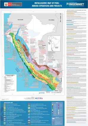
Metallogenic map of Peru: Mining operations and projects
May-2022
The Metalogenic map of Peru at a scale of 1:1,000,000 (De Las Casas & Ponzoni, 1969), sponsored by the National Mining and Petroleum Society, has continued metallogeny studies with new versions of maps by Bellido, E. (1972), Ponzoni, P. (1980) and Canchaya & Aranda (2001). In 2001, within the framework of the Andean Multinational Project, a 1:1,000,000 scale metallogenic map of the border region between Argentina, Bolivia, Chile and Peru was prepared (Zappettini et al., 2001). Later, Cardozo (2002) presented a map with mineralized bands based on deposit types. In the years 2007 and 2008, Quispe et al. prepared a new metallogenetic map featuring 23 metallogenetic belts related to geotectonic domains and regional fault systems, as well as a classification of ore deposits by mining operations and projects. Since then, this map has been updated with new information, and currently the 2009 metallogenetic map has a digital version, which includes information on the size of the deposit based on the tonnage of fine metal content. This version also has a classification of mining operations and projects by type of deposit, in addition, it has information on the metal production of the 23 metallogenetic bands that are presented in this report.
Instituto Geológico, Minero y Metalúrgico - INGEMMET

Files in This Item:
File Description SizeFormat 
2022-Metallogenic_map_Peru_minning_operactions.pdf16.2 MBAdobe PDFView/Open


This item is licensed under a Creative Commons License Creative Commons